The Sussex countryside - an ancient landscape.
Sussex, England visiting family and friends in the part of the world that I grew up in. Home is now New Zealand but during restless nights when I can't sleep I visualise the childhood walk I'm about to take. It's a short walk of an hour or so and starts in the village of Clayton at the base of the South Downs, parking in a small lane called Underhill Lane made famous by Raymond Briggs, when a snowman flies over it with a small boy on the way to the North Pole to visit Santa. This is a brief 2 week trip back to the 'home country' and it has reinforced how important the childhood landscape is in terms of personal development. This walk is full of historical and environmental interest but it is also full of memories that has helped form the adult me.

The South Downs are a line of chalk hills that stretch between the counties of Sussex and Hampshire just inland from the English Channel. And it was only fairly recently that I realised how silly it sounded to say that I was going for a walk up the downs. The word 'downs' originates from the old English word 'dun' meaning a hill. So you can go up the downs!
The start point of the walk is the 11th Century Clayton church complete with the remains of wall paintings depicting biblical scenes, dating from a time when the congregation could not read. Clayton these days though is a noisy place with a busy road and the main London to Brighton train line passing through it. A short walk from the church and you look into the mouth of Clayton Tunnel as the train line goes underneath the hillside.


The portal of Clayton Tunnel is castellated and turreted and has a private cottage perched directly over the line – the whim of the landowner who said that yes you could build the tunnel but only if you also built this folly. As a child mum encouraged us to eat by pretending a laden spoon was a train, our mouths being the tunnel entrance. It's a tradition we also used with our children!
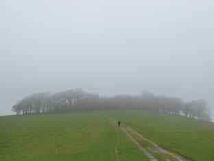
Beyond Clayton a footpath heads straight up to the top and Wolstonbury Hill the remains of an iron age fort. In the meadows are a flock of Downland sheep with their sheep bells tinkling, accompanied by the distant roar of the motor car.


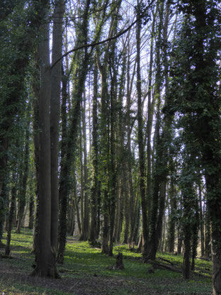
Public footpaths in Britain are legal rights of way and criss cross the countryside. They are ancient ways dating from before cars and even carriages. They connected farms, communities and churches when the only way to travel was by foot. They are amazing historical features as well as enabling access through private land. The footpath to Wolstonbury Hill goes steeply through and ash and sycamore wood.
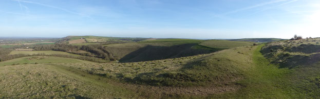
Beyond the hillside is open grassland, with craters and dips where as children we had picnics and played war games. The craters reputedly were made by Second World War bombs! From here it's a short ascent to the top of the hill and the iron age fort itself, the outer walled defences still clearly visible circling the high point.
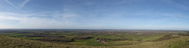
The view north from here is a tapestry of my childhood. The town of Burgess Hill where I grew up, much of the countryside now swallowed up by housing estates. The village of Ditchling and its Common where before I was born, and in more prosperous times, our family had a dairy farm. On the Common a small pond called Caddocks where I first learnt to fish. The village of Hurstpierpoint with its college and prominent church steeple, and where dad used to work. Ashdown Forest to the east – not a forest but an area of sandstone heathland and the setting for AA Milnes 'Winnie the Pooh' stories. The whole area is called the Sussex Weald and is a patchwork of towns, villages, woodland, lanes and fields – and it's all very familiar.


From the top of Wolstonbury Hill are clear views to west and east. To the west – Devils Dyke where the devil tried to breach the Downs and flood the inland – beyond this the natural valley gap as the River Adur heads to sea, another childhood fishing spot. Beyond again to the wood circle that denotes Chanctonbury Ring a former Roman Palace built on the remains of another Iron Age fort. Below this the village of Steyning where family still lives. Another recent walk remembered with Jim through horizontal rain to Chanctonbury Ring and then through a small secluded wood carpeted with the white stars of wood anemones and the pungent smell of crushed wild garlic, leading to another 11th Century church at Buncton accessible only by foot.
To the east are Jack and Jill, 2 windmills perched on the hill. Beyond this the highest point of the South Downs – Ditchling Beacon. The path leads across the hillside to the windmills from which it's a short and steep walk back to Clayton and the start point.
Chanctonbury Ring in the rain.
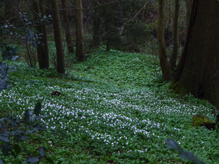
Wood anemones and the lush green of wild garlic.
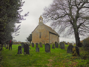
Buncton church, accessible only on foot.
Looking down from the top of Wolstonbury Hill it is very clear how important this landscape is to me. Its the environment in which, with family and friends, I learnt and grew up in. I don't live here now, and for many reasons choose not to, but part of me belongs here, it is part of my inner landscape.